Relic point Vietnam
Việt Nam
Memorial House of General Secretary Le Duan
General Secretary Le Duan's memorial area is located on the banks of Thach Han River, in Hau Kien village, Trieu Thanh commune, Trieu Phong district, Quang Tri province. The memorial relic area of General Secretary Le Duan was recognized as a national relic on October 29, 2010. Le Duan (1907 - 1986) was a son of Bich La Dong village, Trieu Dong commune, Trieu Phong district, Quang Tri province. Born and raised in a land with a rich patriotic tradition, Le Duan soon became enlightened about the revolution. In 1928, he joined the Vietnam Revolutionary Youth Association and became one of the first class members of the Communist Party of Vietnam. A life of vibrant revolutionary activities is closely linked to the history of revolutionary struggle as well as the cause of national liberation and building Socialism of the Party and country. During 26 years, as First Secretary and then General Secretary, no matter what the circumstances, comrade Le Duan always upheld the steadfast spirit of communists, especially those who contributed to it. Your great contribution to the revolutionary cause of national liberation, national reunification, and bringing the whole country forward to build socialism initiated and led by the Communist Party of Vietnam. Le Duan deserves to be an outstanding leader of the nation, a steadfast soldier of the international Communist and workers' movements and an outstanding son of his homeland Quang Tri. "Relics of General Secretary Le Duan's memorial area", is the common name for a complex of relics including: Comrade Le Duan's memorial house - the living place of comrade's family since moving from Bich La Dong to Hau Kien is now a place to worship two of his parents and comrades in his hometown, Hau Kien village; The memorial house is a place to hold ceremonies and visit visitors; The additional gallery is a place to display artifacts and photos related to comrade Le Duan's life and career. The memorial house of late General Secretary Le Duan is located on an area of 2,000 square meters. Formerly the house and garden of Le Hiep's father. The house is made of wood, quite spacious. Through two brutal wars, the house was burned many times, and after liberation, only the floor remained. In 1976, to show respect and gratitude for his great contributions to the Party and State, the Party Committee and people of Trieu Phong district joined hands to help rebuild his family's house on the ground. old. The house is structured in the form of an old bank, consisting of 3 rooms and 2 wings, with a back house (lower house) 4.5m wide, 9m long, thatched roof, bamboo walls, plastered with mud and wood. Inside the house, furniture such as beds, beds, tables, altar cabinets, etc. were restored. At the end of 1977, the thatched roof was damaged and the District People's Committee replaced it with moldy tiles. From 1978 - 1985, it continued to undergo many repairs and renovations, replacing bamboo walls with pressed wood. In 1995, the Quang Tri Provincial Museum restored the house based on the structure of the old house (four or two wings, with a back house) 10m wide, 12m long, each room 2.5m wide, each wing 1m wide. .5m with awning. In 2005, the planning, construction, restoration and embellishment of the memorial site of General Secretary Le Duan was completed, and a number of artifacts and documents previously displayed in the memorial house were transferred to display at the Exhibition House. additional. The memorial house is still used as a place to worship his parents and comrade Le Duan. The memorial relic area of General Secretary Le Duan is a historical relic commemorating typical famous people of Quang Tri province, linking the youth and years of revolutionary activities of the comrade in his hometown with the existence and developing the revolutionary struggle movement of the Party Committee and people of Quang Tri in the two resistance wars against French colonialism and American imperialism. Source: Quang Tri Provincial Museum and Monument Management Center
Quang Tri
7780 view
Rating : National monument

Vinh Moc Tunnels
Vinh Moc Tunnels and Vinh Linh Tunnel Village System are magnificent underground military structures, born during the resistance war against the US to save the country. With the slogan "militarize the entire population, fortification of the entire region" Vinh Linh's army and people have dug trenches, with many functions: headquarters, logistics warehouses, schools, hospitals, living areas. of each family..., arranged throughout the residential areas, along the roads, along the fields, and on the coast, connected by a network of trenches instead of roads on the ground. From the end of 1965 to 1968 (according to incomplete statistics), the entire Vinh Linh district had 114 tunnels with a total length of more than 40km, a trench system of more than 2,000km and hundreds of other tunnels, which became "tunnel village" - appeared for the first time in the history of the Vietnam War, expressing the will to "not move one inch, not leave one inch" to stay and fight to protect the homeland and keep blood vessels open to the front line. Vinh Moc Tunnels and Vinh Linh tunnel village system are distributed throughout 15 communes and towns of Vinh Linh district, Quang Tri province, including: 1. Vinh Moc Tunnel (Vinh Thach). Belongs to Vinh Moc village and Son Ha village, Vinh Thach commune. Includes 13 doors (6 doors open to the hill, 7 doors open to the sea). Along both sides of the tunnel, there are small niches enough for 2 to 4 people. In the basement there is also a hall (capacity of 50 to 60 people), a place for meetings, watching movies, performing arts... and a number of other works such as: bulletin board, maternity home, 3 water wells, toilet, surgery station, infirmary, cooking kitchen (Hoang Cam kitchen). In addition to the underground tunnel and tunnel system, Vinh Moc Tunnels also has above ground works such as trenches, artillery emplacements, breakwaters, exhibition houses... 2. Hien Dung tunnel system (Vinh Hoa). Located in Hien Dung village, Vinh Hoa commune, including 2 tunnels: The tunnel of the People's Armed Police Command in Vinh Linh area is about 1,540m long, including 18 up and down doors and 15 ventilation wells. The People's Armed Police Information Tunnel in Vinh Linh area has 8 up and down doors and 10 ventilation wells. 3. Huong Nam tunnel system, Troong Mon - Cua Hang, Rooc village and Hai Quan tunnels (Vinh Kim). Including Huong Nam Tunnel: belongs to Huong Nam village, Vinh Kim commune. Troong Mon tunnel system: located close to the coast of Vinh Kim commune. Cua Hang Tunnel: The tunnel axis runs East - West, with 2 doors. Rooc village tunnel: belongs to Rooc village Naval Tunnels: These tunnels are located close to each other within a radius of 50m including: Naval Tunnel 1, Naval Tunnel 2, Naval Tunnel 3, Naval Tunnel 4. 4. Mui Si tunnel system, tunnel 61 (Cua Tung town). Including Mui Si Tunnel: located on the coastal road from Cua Tung to Vinh Moc Tunnel, in Thach Ban neighborhood, Cua Tung town. Tunnel 61: located on the road leading to Ben village, An Hoa 2 neighborhood, Cua Tung town. 5. Naval Tunnels (Vinh Nam). Located on a hill in Nam Cuong village, Vinh Nam commune. Vinh Moc Tunnels and the Vinh Linh underground village system are historical evidence of strength, indomitable spirit, the unyielding will to hold on to the land to defend the village, the unique creativity of the people's war, and a shining symbol of revolutionary heroism, greatly contributing to the victory of the resistance war against America to save our nation. With particularly typical values, the historical relics of Vinh Moc Tunnels and Vinh Linh Tunnel Village System (Vinh Linh district, Quang Tri province) have been ranked as special national relics. Source: Department of Cultural Heritage
Quang Tri
7880 view
Rating : Special national monument
DOC MIEU MILITARY BASE
Doc Mieu military base is located in Gio Phong commune, Gio Linh district, Quang Tri province. This historical site is quite famous and is considered an "impregnable fortress" during the resistance war against the French colonialists and American imperialists. Located east of National Highway 1A, about 7km south of Hien Luong Bridge, Doc Mieu is a basalt hill located in a terrain area consisting of three zigzag slopes. This is also the defense line built by the US called Namara - the name of a general commanding the US - Puppet army, to prevent all reinforcements from the North and the Southern battlefield. Among them, Doc Mieu military base is the most important base in this line. Here, the enemy built a system of vaulted tunnels and mobile blockhouses made of concrete. Along with that is an artillery battle towards the north bank of the Ben Hai River, a control center to protect the fence, an armored patrol squad, and many American and puppet companies deployed. Surrounding the base are barbed wire fences with 12 layers of 3m high, on top is a fence with automatic mines, under the fence is a dense minefield hundreds of meters wide. In 1972, our army and people simultaneously opened fire, fired DKD grenades, A12 grenades, and rocket launchers, surrounding the Doc Mieu military base. After three consecutive days of attacks, the enemy had to flee on the night of March 31, 1972, leaving behind their posts, associates, and modern electronic fence system. Currently, our government built a victory monument to recognize the soldiers who fought heroically. At the foot are long, straight rubber hills, proof of the vibrant revival of life in this once-torn land. Doc Mieu military base relic has become a historical tourist attraction for tourists to visit every time they come to Quang Tri. This is not only a symbol of our nation's indomitable fighting spirit but also has profound educational significance for the country's future generations. Source: Quang Tri Newspaper
Quang Tri
8227 view
Rating : National monument

Truong Son National Martyrs Cemetery
Truong Son Martyrs Cemetery is located on Ben Tat hill, next to National Highway 15, in Vinh Truong commune, Gio Linh district; about 38km northwest of the provincial center (Dong Ha town); about 20km northwest of National Highway 1A (in Gio Linh district town). After the day of national reunification, the Party Central Committee and the Ministry of National Defense approved the project to build the Truong Son martyrs cemetery in Quang Tri province as a place to commemorate and honor the beloved children of the heroic homeland. Bravely sacrificed his blood on the Truong Son roads for the cause of national liberation. Construction of the cemetery began on October 24, 1975 and was completed on April 10, 1977. The construction commander is the 559th Division Command with the participation of more than 40 main army units and local soldiers. There is also a group of workers specializing in engraving words on stone stele in Hoa Hai commune, Hoa Vang district, Quang Nam province. Truong Son Martyrs Cemetery is where 10,333 graves of martyrs gather; has a total area of 140,000m2; Of which, the grave area is 23,000m2, the monument area is 7,000m2, the green tree planting area is 60,000m2, the lake area is 35,000m2 and the paved road network within the cemetery grounds is 15,000m2. The grave plot is divided into 10 main areas. Truong Son Martyrs Cemetery is the eternal resting place of the soldiers who sacrificed their lives on the Ho Chi Minh Trail during the anti-American era to save the country. This is the most massive, largest-scale, highly artistic gratitude project, expressing the deep remembrance, gratitude and secret honor of the entire Party, the entire army and the entire people of our country. with our beloved children in all parts of the country who spared no blood for the cause of the struggle to liberate and unify the country. On the occasion of the 40th anniversary of the founding of the Truong Son army (May 19, 1959 - May 19, 1999), the Party and State decided to upgrade and renovate Truong Son cemetery including many items: Entrance gate to Truong Son cemetery, road system and surrounding wall, command post model, local symbols, statue clusters, drainage system, internal electricity, planting trees around the cemetery and houses celebration, Fatherland Radio recognized... Up to now all items of the project have basically been completed. Truong Son Martyrs Cemetery today is not only the resting place of heroic martyrs but also a place of worship, a shining symbol of revolutionary heroism, of the spirit and will to fight for independence. independence and the desire for peace of our people. Truong Son Martyrs Cemetery is not only a place for martyrs' families, Party and State delegations, and local governments to visit and perform gratitude work, but also a place of pilgrimage. of people all over the country and international friends following the noble moral tradition of the Vietnamese people: when drinking water, remember its source. Currently, Truong Son Martyrs Cemetery has 24 officers and employees who regularly take care of, repair and welcome martyrs' families and domestic and foreign delegations to visit. Source: Office of the People's Committee of Quang Tri Province
Quang Tri
7982 view
Rating : Special national monument

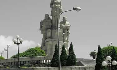
Ta Con Airport
Ta Con airport relic area is located in Hoa Thanh village, Tan Hop commune, Huong Hoa district, Quang Tri province. With a terrain like a valley surrounded by hills and mountains, Ta Con airport was one of the strategic military bases of the US army in the years 1966 - 1968 at the Khe Sanh battlefield. Near the border, located on National Highway 9 connecting Dong Ha (Vietnam with Southern Laos), this place has an important military strategic position not only on the Quang Tri battlefield but also in the Indochina region. That's why Khe Sanh was used by the US military as a springboard for ground operations. Ta Con Airport was built with the purpose of allowing reconnaissance aircraft to check and point out many raiding, blocking and cutting off Ho Chi Minh routes. In particular, located in the Namara electronic fence system stretching from Cua Tung beach to the border area, Khe Sanh base is determined to be the center. Therefore, the US military built the most solid defense group in the US in the southern region of Vietnam, including bases: Lang Vay, Huong Hoa Military Branch - a cluster of defensive bases at Ta Con airport. . And the Ta Con stronghold cluster - Ta Con airport, is considered a construction center with a scale of 2km long, 1km wide, including many sub-bases with dense fortifications and a large airport. The airport has an area of about 10,000 square meters located in the middle of the base with a runway paved with thousands of tons of aluminum and iron rims. This place became the take-off and landing place for armed helicopters, combat jets and even heavy military transport aircraft such as C130 and C123. In the airport area, there is a base command headquarters, an airport command post, a communication station... and a dense system of defensive fortifications. Outside is a loose wire fence and large minefields. Along with modern military equipment and an important location, Ta Con airport and adjacent high points formed a continuous, mobile defense position, considered by the US and puppet troops at that time to be the most important. the most "hard" position in the entire Khe Sanh base group system. And Ta Con airport is considered by the US military as an invincible fortress Here, faced with the power of the Vietnam People's Army's attacks to liberate Khe Sanh from February to July 1968, the US military had no choice but to launch a tactical withdrawal by air force to saved thousands of American soldiers. Exactly 55 years ago, on July 9, 1968, our army's victory flag flew over Ta Con airport base. The Route 9-Khe Sanh campaign ended with a resounding victory. Khe Sanh - Huong Hoa was the first district of Quang Tri and the South to be completely liberated and created firm confidence for our army and people to advance to complete victory, liberate the South, and unify the country. At the current Ta Con airport relic site, the Museum of Street 9 - Khe Sanh is a place to display hundreds of valuable historical and scientific artifacts. Along with that, the tunnel system, air traffic observation tower... were restored within the airport campus. In 1986, Ta Con airport relics were ranked as national relics. This place also displays outdoor artifacts such as airplanes, tanks, artillery and dozens of bomb and bullet casings. These are the weapons and means of war that the US military used to fight at the Khe Sanh - Ta Con battlefield 55 years ago. Source: Ministry of Culture, Sports and Tourism
Quang Tri
5126 view
Rating : National monument

Lao Bao Prison
Lao Bao Prison Relics, also known as Lao Bao Exile House, is located southwest of Road 9, next to the Se Pon River, in Duy Tan village, Lao Bao town; The monument was ranked National on January 25, 1991. During the feudal period, Lao Bao was a border post of the Nguyen Dynasty, used to guard a part of the western border of the country, and also used as a place to exile criminals with heavy sentences. Since the French colonialists placed protectorate over Vietnam and officially opened Route 9 (in 1904), after 4 years, the colonial government began upgrading Bao Tran Lao during the Nguyen Dynasty into a Lao prison. Bao (1908). When first established, Lao Bao prison had only two rows of wooden cells, tiled roofs, and plastered walls, called Lao A and Lao B; Each row of buildings is 15m long, 5m wide, 2m high and can hold 60 prisoners. Since the birth of the Communist Party of Vietnam, many revolutionary movements broke out throughout the Central region, and the French colonialists increased their hunting, arrests, and suppression of the revolution. To serve the detention of prisoners who are members of the Communist Party. At the end of 1934, they built an additional system of solid prisons made of concrete and reinforced steel, prisons C, D, cellar E; Each prison is 30m long and 6m wide. Detain about 180 prisoners. And the solitary confinement area has 13 rooms, each room is 1m wide, 2.14m high. All buildings are surrounded by a 3.5m high solid wall system and many protective bunkers at the corners and walls. important position. In addition, there are a number of other service works such as: the Commander's House, torture and interrogation house, barracks, warehouse, carpentry workshop, blacksmith workshop... These works are located on an area of more than 10 hectares. Lao Bao Prison is one of the five largest prisons in Indochina, imprisoning patriots and communist soldiers of the Central region. With the harsh climate, wild mosquitoes, flash floods, and harsh prison regimes such as brutal torture and heavy forced labor; Bad food, illness and no medicine have tortured people's bodies to death... Lao Bao prison has become a living hell for prisoners. For nearly 40 years of existence, Lao Bao prison has imprisoned thousands of Communist soldiers and patriots. Through two wars, especially during the war against the US, Lao Bao Prison was almost completely destroyed, many buildings only had part of their architecture remaining such as: Lao C, D, E, Question House. palace, solitary confinement area, some bunkers... but most have been deformed and become abandoned. Today, in addition to the evidence of the crimes committed by the enemy against our nation, there are also a number of new constructions built here to serve the work of preserving and promoting the value of relics such as: Additional displays, Monument cluster, Stele house, Reception house... Lao Bao Prison is living evidence of the crimes of the French colonialists against our people in the first decades of the 20th century. Source: Quang Tri Newspaper
Quang Tri
4784 view
Rating : National monument

The banks of Hien Luong - Ben Hai
The Hien Luong - Ben Hai Banks Relic is located in Vinh Linh district (Vinh Thanh, Vinh Giang, Vinh Son communes, Cua Tung town) and Gio Linh district (Trung Hai commune), Quang Tri province. Hien Luong - Ben Hai is a place that witnessed the pain of division between the two regions and historical events associated with the process of fighting for national liberation and unification of our army and people during the anti-American period - Wei. After the Geneva Accords were signed (July 20, 1954), our country was temporarily divided into two regions, North and South, taking the 17th parallel (Ben Hai River) as the boundary, waiting until October. In July 1956, general elections were held to unify the country. But with the events caused by the sabotage of hostile forces, it took us 21 years (1975), with the blood of soldiers and compatriots, to gain independence and unity. country. The main axis of this monument lies in the North - South direction, with the center being the historic Hien Luong Bridge - the span connecting the Northern Flagpole and the "Aspiration for Unification" monument cluster on the Southern bank. The main components of the monument include: 1. Area on both banks of Hien Luong bridge: Including the following relics: Hien Luong Bridge, Union House, Hien Luong flagpole, North bank loudspeaker system, Hien Luong Police Station, "Latitude" exhibition house 17 and the desire for unity", South Coast Police Station, Monument Cluster "The Desire for Unity". 2. Cua Tung Police Station. Currently, the Cua Tung Police Station location belongs to Border Guard Station 204 barracks. In addition to the function of working and staying, the project also serves national security purposes. The lower floor of the two-story building is partly reserved for the Station's Traditional House, displaying 92 documentary photos and 60 artifacts directly related to the history of the revolutionary struggle of officers and soldiers of Cua Police Station. Tung, posts and stations along the North bank of Ben Hai River and Border Guard Station 204 since 1954. 3. Ferry wharves on Hien Luong River - Ben Hai: Including the following relics: Cua Tung wharf (Ferry A), Tung Luat wharf (Ferry B), Luy wharf (Ferry C), Wharf Thuong Dong and Duc Duc boats. 4. The monument includes: a pedestal and a symbolic artistic complex, with the image of boats rushing forward, despite all dangers and enemy bombs, bringing goods and equipment at night. team entered the battlefield to fight the Americans. In addition to preserving and embellishing relics, the Unification Festival is periodically held at the relic on April 30 every year (normal years are organized by the locality, even years are organized by the Ministry of Culture and Sports). and Tourism and the People's Committee of Quang Tri province co-organised). This is a unique revolutionary festival, unique to the Hien Luong - Ben Hai banks relic site, Quang Tri. With the special values of the relic, on December 9, 2013, the Prime Minister ranked the Hien Luong - Ben Hai banks historical relic (Vinh Linh district and Gio Linh district, Quang Tri province) as a relic. special national monument. Source: Department of Cultural Heritage
Quang Tri
4686 view
Rating : Special national monument
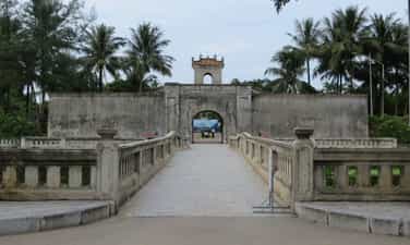
Quang Tri ancient citadel
Quang Tri Ancient Citadel relic is located in the heart of Quang Tri town; nearly 1km northeast of National Highway 1A, about 14km southeast of Dong Ha city - the capital of Quang Tri province today. Quang Tri Ancient Citadel was built during the reign of King Gia Long and was completed during the reign of King Minh Mang, lasting nearly 28 years (1809-1837). The citadel was initially covered with soil, and in 1837, King Minh Mang rebuilt it. with bricks. The citadel's campus has a square shape with a wall circumference of 2160m long, the citadel is 3m high, 13.5m thick at the base, and 0.72m thick at the top. Outside the citadel, there is a wide moat system surrounding it. The four corners of the citadel are four high fortresses jutting out. The citadel has 4 gates: Front, Back, Left, Right. Built with a rolling arch, 3.4m wide, above is a gazebo, curved roof, tiled, all 4 gates are located in the middle of the 4 sides of the Citadel. During the period of French colonial domination, Quang Tri Citadel served as the nerve center of the local and provincial governance apparatus. Quang Tri Ancient Citadel was chosen by the French army as one of the important bases of the military station system. France built an additional prison system, expanded and solidified the prison to serve as a place to detain patriots and revolutionary soldiers in the province and region. Quang Tri Prison at one time became the center of leadership of the revolutionary movement because this was the place where the core core of youth, the first communist soldiers of Quang Tri and many leaders of the Communist Party of Vietnam were detained. The Provincial Party Committee and the Regional Party Committee belonged to the pre-uprising period. Coming to the American - puppet period. After the Geneva Agreement was signed on July 20, 1954, according to the agreement, the 17th parallel was used as the temporary dividing line. A part of Quang Tri from Ben Hai River outward was liberated, the districts from Gio Linh back to Hai Lang became a new type of colony of the American empire. Quang Tri Town, including Quang Tri Ancient Citadel, became the political, military, economic and social center. The US - puppet transformed the Citadel into a military zone, used it as a military warehouse and command center for the entire province, and opened more prisons to suppress the revolutionary movement. The 1972 strategic offensive across the South began. On April 28, we captured Dong Ha and approached Quang Tri town. On May 2, Quang Tri Town was liberated. The victory of the Quang Tri campaign in 1972 fundamentally changed the battlefield situation, pushing the US strategy of "Vietnamization of the war" to the brink of bankruptcy, creating momentum and room for the complete liberation of the South. . Having lost Quang Tri, the US-puppet crazily launched a counterattack to recapture Quang Tri with the code name "Lam Son 72". The number 1 goal is to capture Quang Tri Ancient Citadel. Quang Tri town during the 81 days and nights from June 28 to September 16 was likened to a bag of bombs. On average, every day the enemy mobilized jet planes 150-170 times and B52s 70-90 times to bomb and destroy the town and Quang Tri Ancient Citadel. With an area of less than 3 kilometers, in 81 days and nights, the town and Quang Tri Ancient Citadel had to bear 328,000 tons of bombs and bullets, on average each of our soldiers had to bear 100 tons of bombs and 200 artillery shells. We were determined to keep the city, while the enemy tried to capture the city at all costs. Thousands of soldiers sacrificed their lives here, but their remains have not yet been retrieved because there was too much smoke, fire, and bombs. Their blood and bones have mixed into the rubble and rubble. That's why today at the center of the monument, people built a memorial to form a common grave for thousands of soldiers who fell during these fierce days and nights. This mass grave was designed according to the concept of yin and yang philosophy, which has a profound meaning to escape the souls of the deceased. There are 81 stairs going up, symbolizing 81 days and nights of fighting in Quang Tri ancient citadel. Source: Quang Tri Provincial Museum and Monument Management Center
Quang Tri
5292 view
Rating : Special national monument

Le Thanh Phuong Temple
The historical relic of Le Thanh Phuong's tomb and temple is located in My Phu village, An Hiep commune, Tuy An district, Phu Yen province. The relic was recognized as a National Historical-Cultural Monument in 1996. Le Thanh Phuong is the leading historical celebrity in Phu Yen province. He was born in 1825 in My Phu village, Xuan Vinh canton (now My Phu village - An Hiep commune - Tuy An district - Phu Yen province) in a family of Confucian scholars and rich in patriotism. Passing the baccalaureate exam at the age of 30, he returned to his hometown to open a teaching school. In 1885, in response to King Ham Nghi's Can Vuong edict, Le Thanh Phuong stood up and gathered the Phu Yen insurgents to raise an uprising flag against the invading French colonialists. He was appointed "Marshal of Military Affairs" by King Ham Nghi. With Le Thanh Phuong's talent, after only 1 month, he gathered several thousand people to raise the flag of rebellion. At that time, everyone knew him by the title "Marshal of Military Affairs". He divided the combat zone into two zones, one is from Cu Mong pass to Tam Giang pass, the other is from Tam Giang pass to Ca pass. In just a short time, his uprising many times frightened the French enemy. In February 1887, Le Thanh Phuong was captured by the enemy due to an informer. On February 20, 1887 (January 28, Dinh Hoi year), because he could not seduce and bribe him, the Vietnamese traitor Tran Ba Loc ordered the execution of Le Thanh Phuong and many other patriotic scholars at Ben Cay. Coconut (in An Dan commune, Tuy An district today). The uprising organized and led by Le Thanh Phuong in Phu Yen was an important part of the nationwide Can Vuong movement, having a positive and strong influence on the Can Vuong movement in the South Central provinces. Le Thanh Phuong's uprising is a glorious page in the history of the extremely heroic and heroic struggle against foreign invaders for national independence of the Phu Yen people and will forever be the pride of the Phu Yen people. He set a shining example of indomitable will and heroic spirit of sacrifice for the people and country. Le Thanh Phuong's Tomb and Temple relic in My Phu village - An Hiep commune - Tuy An district - Phu Yen province was officially recognized by the state as a national historical-cultural relic in 1997. Since then, it has become a tradition that on January 27 and 28 every year, Tuy An district and An Hiep commune authorities coordinate with the Department of Culture, Sports and Tourism of Phu Yen province to organize a memorial ceremony to the "Marshal of Military Affairs" Le Thanh Phuong, the beloved son of his hometown Phu Yen. This is also an opportunity for people everywhere in Phu Yen province, especially Tuy An district, to gather to participate in traditional activities and organized folk games such as: Pushing sticks, men's and women's tug of war, walking. stilt walking, three-legged running, running and hula hooping, marching while cooking, Chinese chess and human chess competitions, beautiful camping, folk singing competitions, hut card festival and art festival. Source: Phu Yen Tourism Information Promotion Center
Dak Lak
9557 view
Rating : National monument
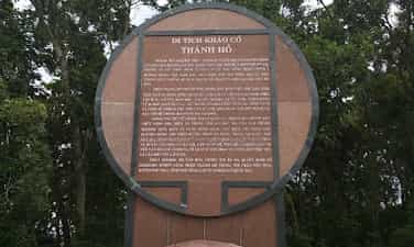
Thanh Ho
Thanh Ho is located on the north bank of Da Rang River, in Dinh Tho village, Hoa Dinh Dong commune, Phu Hoa district, Phu Yen province. Ho Citadel is a citadel with a roughly rectangular plan, the walls of the citadel are in the correct directions of east - west - south - north. The south side borders the Da Rang River, the west borders mountains, the north and east sides border flat fields. In addition, there is a fifth citadel running north - south, dividing Thanh Ho into two parts: The western part is also called the inner citadel, the eastern part is also known as the outer citadel. The north citadel has a length of 726m, the same width and height as the east citadel. The southern citadel has collapsed into the Da Rang River, only a part remaining in the southwest corner, 250m long. The west wall runs around the west side of Hon Moc, divided into two sections: The first section from the southeast corner to the western foot of Hon Moc is 600m long; The second section runs diagonally in the northwest corner connecting the west wall and the north wall. The 5th wall is the middle wall, 920m long. West of the Lake Citadel within the inner citadel area, there is also a small mountain called Hon Moc, about 60m high. On top of Hon Moc, there are many construction materials of an ancient architectural work. On the walls of the citadel today, there are still traces of watchtowers. Outside the north and east walls, there are traces of moats as a defense system supporting the wall. Thanh Ho has been studied by researchers for a long time. The book Dai Nam Nhat Thong Chi describes Ho Citadel as follows: “An Nghiep ancient citadel: north of Da Dien river, in An Nghiep commune, Tuy Hoa district, circumference of 1400 truong; Legend has it that it was built by the Champa people, and is commonly called Ho Citadel... Now the old foundation still exists..." In recent years, research on Ho Citadel relics has continued to be promoted. In 2003 and 2004, the Institute of Archeology and Phu Yen Museum coordinated excavations at Ho Citadel, finding traces of ancient architectural works buried in the ground at a relatively high density. The excavation also recovered a large number of civil and architectural ceramics, including tube tile heads decorated with many different motifs. These tube tile heads date back to the 5th to 7th centuries. In addition to the antiques found during excavations, many antiques within the Ho citadel relics have also been discovered in recent times. Most recently, in early 2006 in the Hon Moc area, 4 ancient statues were discovered. These statues date back to the 7th to 10th centuries. Results obtained through surveys and research have confirmed that Ho Citadel was built very early; possibly in the 4th century and existed for about 10 centuries until Vietnamese people began to live here. The research results have also confirmed the multifaceted value of the Ho citadel relics. Certainly Ho Citadel still contains many historical and cultural values. The recognition of the Ho Citadel relic as a national archaeological historical site will be a favorable condition for continuing to research and promote the cultural and historical values of this citadel. Source: Phu Yen electronic information portal
Dak Lak
5129 view
Rating : National monument